
By MICHAEL SCHREIBER
This is the second of a series of articles on the history of the western portion of Franklin D. Roosevelt Park, at the southern tip of Philadelphia, near the confluence of the city’s two major rivers. As explained in our first article, the city is radically transforming that portion of the park (nicknamed “the Meadows”). Some of the city’s plans might have a positive outcome, in that the plan calls for an expansion of wetlands in the southern section of the Meadows. However, the work has been carried out with little sensitivity to the natural environment and with a brazen indifference to public dialogue. Construction crews have already caused tremendous environmental devastation. Large areas have been denuded of trees, and the land has been raised, flattened, and compacted in order to construct the city’s main objective—a complex of 16 athletic fields, buildings and game courts, and new roads and parking lots.
1. Introduction: Description of the terrain
FDR Park lies on low and relatively flat land that formed part of the delta of the Schuylkill River, as it filtered through many channels and creeks, and around many islands and reed-covered sandbars, into the Delaware. As Philadelphia grew, many of the river channels were filled in to make more land, while most of the creeks were buried and diverted into sewers. Sections of two of the creeks, Hollander’s and Shedbrook, still flow in FDR Park, although Hollander’s was dammed in several places in the early 20th century to form what are popularly known as “The Lakes.”
At the time that the first European settlers saw it, Hollander’s Creek was open to the Delaware River’s back channel and relatively deep and wide; it even accommodated ocean-going ships. A brig was reported to be unloading in the creek as late as 1840, but such traffic was cut off soon afterward when a dam and floodgate was erected at the mouth of the creek (authorized by the Pennsylvania Senate in 1839).
According to several 17th-century maps, the Indigenous people at the time, the Lenni Lenape, called that creek “Kikitchemus,” which has been translated to mean “wood duck,” while other old maps label it “Kwinkwingus,” the “place of large ducks.” The creek, or one of its branches, was also identified in Dutch land deeds of 1654 as Moyamensing Kill, (“moyamensing” is often translated as “the place of pigeon droppings.”). The name “Hollander’s” also dates to around that period. Some contemporary sources traced the latter name to the word describing the Dutch settlers of the region (hence, the Swedish name, “Hollendaren Kylen”). However, it is more generally thought that the creek was named after Peter Hollendaer, who, although he was a Dutchman, served as the second governor of New Sweden (1640-43).
Through its many tributaries, Hollander’s Creek drained a large section of what is now South Philadelphia. The main tributary was called “Chickansink” and variations of that name (“Chickhansk,” “Chickquasink,” “Shakhansing,” etc.) on early English-language maps. The Philadelphia Sunday Dispatch of Oct. 1, 1848, explained: “Chickansink—that is the name of a small stream which takes its rise near Broad and Federal streets, and flows southwardly though the Neck into Hollander’s Creek. The meaning, in the language of the Delawares [Lenni Lenape], is ‘the place where we were robbed.’”
The Chickansink had its junction with Hollander’s Creek just west of today’s 15th St. and Pattison Ave. entrance to FDR Park, in the vicinity of the present Pattison Lagoon.
A network of small brooks contributed to Chickansink Creek; one extended as far north as 13th and South Streets, while another began around 17th and Spruce Streets. A tributary on the lower end of the creek, which used to run through today’s Packer Park neighborhood, was called Malbore’s (also Malebore’s, Mill Bore, Malbo’s, etc.) Creek. In fact, William Penn referred to the entire area that now includes FDR Park as Malbore’s Point (with a focus on the spit of land at the mouth of the Schuylkill that now is called Girard Point). Malebore was a Lenape leader (or “sackamacker”) who signed an agreement with Penn’s deputy, Thomas Holme, on July 5, 1685, affirming that the land between Chester Creek, Conshohockin hill, and Dublin Creek should be conveyed to the white settlers in exchange for a collection of tools, rifles, beads, tobacco, and other materials. Ten other Lenape leaders and several whites of Swedish and English descent, headed by the farmer Lasse Cock (who later built a house in the area of what is now FDR Park), also signed the document.
In the mid-18th century, Malbore’s Creek ran through the estate of Joseph Turner (born 1701)—a sea captain, merchant, slave trader, Philadelphia city councilman, member of the Pennsylvania Provincial Council, and British Loyalist. His mansion, called Wilton, was noted for its magnificent gardens. John Fanning Watson, in his “Annals” (1857 edition), recorded: “Many fine statues of fine marble [sold from a Spanish prize] were distributed through the grounds and avenues.” After the Revolution and Turner’s death (in 1783), Wilton passed to members of the Chew family, who also owned the adjacent property, White Hall. Both plantations were partly worked by slaves.
A narrow creek that still winds in an “S” pattern through the Meadows area of FDR Park and flows into Hollander’s Creek was called “Ship Brook” until the end of the18th century. Possibly—this is my own conjecture—the name is derived from the English transliteration of the Lenape word for creek, “sipu.” Some later maps called it “Shad Brook” (probably for the fish that spawned in its shallows), and finally, “Shedbrook Creek.” Another creek, running along the western edge of what is now the Meadows area of FDR Park, was Sepenken Creek. It paralleled the ridge where the Province Island Road was laid out in the 18th century (later becoming the Penrose Ferry Road), and flowed into the Schuylkill just below the rope-ferry crossing.
Wetlands covered much of this area, especially along the rivers, with forests and meadows in the upland areas. When, in 1694, William Penn granted a vast tract of land that included much of the present FDR Park to Lasse Cock, he wrote of “a certain parcel of Swamp, Cripple, and Marsh.” These three categories of ecosystems are repeatedly mentioned in deeds and descriptions of the land during the following decades.
A “swamp” refers to forested wetlands. The Atlantic white cedar (Chamaecyparis thyoides) was one tree that used to be prevalent here; it thrives in fresh-water swamps and along streams. Old maps, for example, refer to a portion of the Schuylkill riverside north of the present FDR Park, near the Passyunk Road, as the “Cedar Banks.” According to the Swedish naturalist Peter Kalm, who visited this area in 1748-49, the Lenni Lenape people used the Atlantic white cedar for many purposes, including building canoes. Unfortunately, the European colonists logged the tree to such a degree (principally to make cedar shingles) that the supply of cedar wood was rapidly exhausted and the range of the tree shrank considerably. Today there are no indigenous Atlantic white cedar woodlands remaining in Pennsylvania, though large stands still remain in southern New Jersey.
“Cripple” is an archaic word denoting land that is covered mainly by low shrubs and thickets. Much of the lowlands in southern Philadelphia County contained this type of vegetation until they were cleared for farms and grazing meadows. Journalist and local historian Thompson Westcott, writing in the Philadelphia Sunday Dispatch (March 17, 1867), cited a contemporary, Edward Arnold, in asserting that the word “cripple” was derived from the Dutch word for knotgrass, “kreuple.” He wrote, “The resemblance between the kreuple grass of Holland and the grass which grew here led them to designate as ‘cripple’ the place where it flourished.”
A “marsh” refers to a lowland area that is flooded by the tides or sometimes permanently waterlogged. Plants include herbaceous species such as grasses, sedges, rushes, cattails, and ferns. In the vicinity of today’s FDR Park, most of the area bordering the lower Schuylkill and the back channel of the Delaware (where the tide rose and fell about four feet twice a day) was covered by marsh, and smaller areas of marshlands still survive in sections of the park.
2. Evidence of early peoples
During the last Ice Age, more than 20,000 years ago, this area’s topography was much different from what it is today. At the pinnacle of the Ice Age (the third to advance over North America) massive glaciers covered a third of Pennsylvania; the ice in Northern New Jersey was as much as 2000 feet thick. To the south, there was mainly frozen tundra. The coastal plain reached 60 or more miles into the Atlantic beyond the present shoreline; that is shown by the fact that mammoth teeth have been found on the ocean floor. And the Delaware River, which began in the ice sheets to the north, cut a narrow ribbon to the sea on a slightly different course than today.
As the climate warmed, the sea gradually rose and buried much of the coastal plain. The old channel of the Delaware River became submerged below a much wider and deeper Delaware Bay. And over thousands of years, grass-dominated tundra gave way to stands of spruce, and then pine, and eventually oaks and other deciduous trees. The terrain around what is now FDR Park was likely drier than it is now and covered by forest and meadow.
It is thought that nomadic hunter-gatherers, who used stone tools, first came into the Philadelphia region during the early transitional period from the Ice Age to a more modern climate, within a range of time from at least 10,000 to perhaps 15,000 years ago. The climate at the beginning of what is called the “Paleo-Indian Period” remained cold and rather wet. Many large animals still remained—wooly mammoths and mastodons, saber-toothed cats, bison, musk-oxen, giant beavers, moose, and sloths. But over the years, the continued changes in the environment—including a temporary re-cooling of the environment—and possibly hunting by people, drove them into extinction. It is thought that the mammoths and mastodons vanished about 10,600 years ago.
This epoch was succeeded by the so-called “Archaic Period” of human habitation in the area (approximately 10,000 to 3000 years ago). The climate had continued to warm, though it was still cooler than at present. The continental glaciers had almost completely receded, causing water levels in the rivers and streams to rise. New vegetation covered the terrain. The ancient peoples of this epoch tended to remain longer in camps and villages, and trade was undertaken between different population groups.
Evidence of human habitation from this period has been found in several excavation and construction sites in Philadelphia, including for the National Constitutional Center, the Sugarhouse Casino, and along the I-95 expressway. The latter site, discovered in the Fishtown neighborhood in 2015, contained the remains of an ancient hearth. Radiocarbon analysis found charcoal from the site to have been created around 5500 years ago.
Similar evidence of an open-pit heart oven had been found in 2014 near Washington Avenue in South Philadelphia, about three miles from FDR Park. Archeologists discovered a circular cluster of fire-cracked rock and several layers of river cobbles that had been cracked by intense heat. Radiocarbon dating of organic material at the site indicated that it was in use about 3700 years ago.
Archeologists found additional evidence of the presence of early Indigenous people in studying excavations for a parking garage on Civic Center Boulevard—about three miles up the Schuylkill River from FDR Park—in 2001. Indications were that a large base camp had been located at the site. Stone implements that were found there are thought to date to the period from about 6000 to 2000 years ago.
Excavations at four construction sites in Center City that were undertaken within the past two decades have found stone artifacts and pottery shards dating from around 3000 to 1000 years ago—at the time that the Archaic Period was transitioning into what is called the “Woodland Period.” Items like glass beads were also found and appear to date from a later period, when the area was settled by the Lenni Lenape people (see below).
In the Meadows area of FDR Park, amateur collectors found several stone implements attributed to Native peoples. The artifacts, which I have seen in photos, include a hatchet head and what appears to be a rough stone cutting tool. A round stone ball was also found; it is similar to the ball cores that Lenape men and women used for their game of pahsaheman, which in many ways resembled modern American football.
It is not unlikely that future archeological diggings in the Meadows would discover more artifacts left by the early peoples who lived, fished, and hunted close by. Unfortunately, any such inquiries will be severely hampered due to the current excavations overseen by the city’s Parks and Recreation Department, and its plan to cover a large portion of the Meadows with filled earth in order to accommodate a giant complex of sports facilities.
3. The Lenape and Susquehannocks
Most sources state that around 1000 years ago, a nation of people migrated into the region from the north; they called themselves the Lenape, or sometimes, the Lenni Lenape (“Lenni” is translated as “real” or “the original”, while “Lenape” means “people”). Today, however, the Pennsylvania Lenape dispute the time period in which people of their culture are said to have come into this area, setting back the date to about 10,000 years ago. The people who lived in the vicinity of what became Philadelphia spoke the southern Unami (i.e., “the people down river”) dialect of Lenape, which itself is a branch of the broader Algonquin language group. Localities in this area still retain many of their place names, or Anglicized versions of those names.
The Lenape settled in small villages of about 30 to 40 people that were composed of a cluster of conical wigwams or cylindrical longhouses, made of thatching or skins stretched over bent saplings. Evidence suggests that each longhouse (perhaps 18 to 60 feet in length) was the home of a single extended family, and some researchers believe that an entire village was probably made up of related families. The villages were generally set in the vicinity of the Schuylkill and Delaware Rivers, or near the area’s many creeks, which the Lenape and other Indigenous peoples used for transportation by canoe.
One such settlement was located close to the banks of Sepenken Creek, in the high ground bordering the western edge of what is now the Meadows area of FDR Park. That area was called “Passyunk” (“between the hills” or “in the valley”) by the Lenape. The village was probably extent in the early to mid-17th century, at the period of European contact.
Further up the Schuylkill, on the west bank, was the Lenape village at Arronemink, which was located at the mouth of what the English called Mill Creek (today channeled into a sewer that flows under Clark Park and empties into the river just below Woodlands Cemetery). Arronemink was not far from the much older Indigenous camp at the site described above at Civic Center Blvd.
In the summertime, Lenape villagers from further up the Schuylkill would come to the mouth of the river, near what is now FDR Park, where the wetlands and creeks provided good fishing and hunting. Each band of the Lenape had their own designated hunting and fishing stations. Then in the fall, the hunters would return to the villages to help with the harvest of crops that had been planted the previous spring.
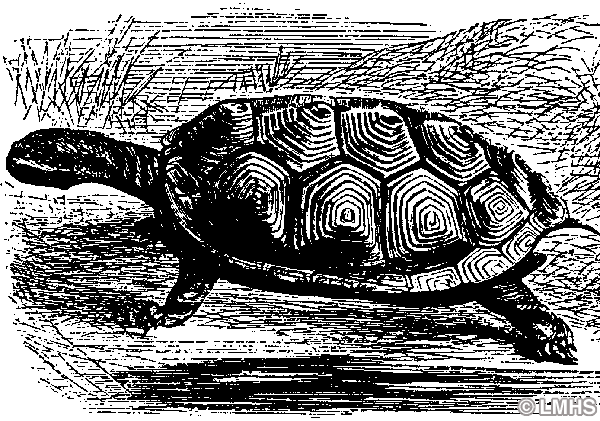
The Lenape had a matrilineal society; men served most often as chiefs or “sachems,” but they were chosen by the elder women. The men did most of the fishing and large-game hunting, and the heavier work—such as cutting trees or clearing fields for planting—but some women participated in those activities too. Women had the major responsibilities of gathering and preparing wild plants for food, teas, and medicines; collecting birds eggs, shellfish, frogs, and turtles; cultivating domestic crops; grinding seeds into flour; pressing nuts for oil; weaving mats and blankets; braiding cord for fish nets; scraping animal hides for moccasins and robes; and making pottery.
The Lenape found many uses for the vegetation in the wetlands where the present FDR Park is situated. Cattails (Lenape: ahpawi), which are still prevalent in the park, have leaves that the Lenape women wove into mats, baskets, and wigwam covers. The cattail stalks were used to create arrow shafts and hand drills. The leaves, young shoots, and roots could be ground into foods, antiseptic ointments, etc., or pounded into flour. The roots could be mashed into a poultice for blisters, cysts, and stings; the flower could be brewed into tea for diarrhea; the pollen was useful as a blood cleanser, taken internally to stop internal bleeding and menstrual pain, or placed on wounds to stop bleeding; and the “fluff” could be used as stuffing for pillows.
Similarly, the Lenape devised many medicinal applications and foods from sumacs. Staghorn sumac (Lenape: Kelelenikanakw, Latin: Rhus typhina or Rhus hirta) and smooth sumac (Rhus glabra) are bushes or small trees that are common in many types of soil in the area, including in open meadows and on the edges of wetlands and streams. The leaves, bark, and berries of both species were used for teas and dyes. Young shoots were eaten as “salad.” The berries were soaked to make a juice or jellies, and the branches were woven into baskets. Parts of the root were chewed to alleviate sore throat, toothache, pyorrhea, canker sores, etc. The leaves, when they turned red in the fall, were harvested and mixed with tobacco for pipe smoking.
The roots of the water lily (Mpiànàxkwim, Nymphaea sp.) could be boiled, and the nuts baked, as food. Rushes (anakànàskw, Juncus sp.) were woven into mats (anakàna) for people to sleep or sit on.
Peter Kalm, writing in 1749, mentioned “mousewood” (better known as “ironwood,” Dirca palustris), “a little shrub which grows on the rising ground adjoining to the swamps and marshes.” He noted that “the bark of this shrub was made use of for ropes, baskets, etc. by the Indians whilst they lived among the Swedes. And it is really very fit for that purpose, on account of its remarkable strength and toughness …”
He also mentioned that “the English and the Swedes of America give the name of Currants to a shrub which grows in wet ground, and near swamps, and which was now in blossom; its flowers are white, have a very agreeable fragrancy, and grow in oblong bunches; the fruit is very good eating, when it is ripe.” He might have been referring to Ribes americanum, known as the wild black currant, which is in the gooseberry family. The berries are edible when cooked, and Native Americans used them for pemmican and jellies. Likewise, the “swamp red currant” (Ribes triste), which has red berries,” was good for jams.
Over the centuries, the Lenape learned to domesticate a number of plants. They often used fire to clear the land for their agricultural plots. After growing crops in one area for a few years, the people would move on to fresh ground. In this manner, Peter Kalm pointed out, they allowed the land to lie fallow, reforest, and in time regain fertility—unlike the European colonists, who exhausted the soil by torching the brush and leaves every autumn and then repeatedly planting crops on the same plots of land.
Major staples included the “Three Sisters”—corn, squash, and beans. The three crops were generally planted together in a cluster, which provided a number of benefits. The bean vines could climb on the corn plants while providing support for the stalks; the nitrogen-fixing bean roots helped to fertilize the soil; and the squash shaded the soil and helped prevent weeds while its prickles helped to dissuade raccoons and other animal raiders. And when they were eaten together, the three vegetables helped to provide a balanced diet (carbohydrates, protein, and vitamins). William Penn wrote: “Their Diet is Maze, or Indian Corn, divers ways prepared: sometimes roasted in the Ashes, sometimes beaten and Boyled with Water, which they call Homine; they also make Cakes, not unpleasant to eat: They have likewise several sorts of Beans and Pease that are good Nourishment …”
Domesticated beans and squash were developed around 700 years ago, whereas corn came to the greater mid-Atlantic region about 3000 years ago, having originated in Mexico. Some researchers believe that the Lenape began to cultivate corn about 1000 years ago in this area, an indication that they might have brought the practice with them when they first migrated into the region.
Corn was planted more often in the northern range of Lenape settlement than it was in the lower Delaware River region, perhaps because the season was longer here to harvest wild comestible plants. After the Swedish settlers arrived (first landing in 1638), the Lenape began growing extra corn to trade for goods such as metal pots and tools or blankets.
The Lenni Lenape saw their economic and social conditions transformed even before groups of Swedish and Finnish farmers had settled in the region. The fur trade, which took hold the early 17th century under the agency of the Dutch West India Company, was pivotal in the process. Since there were not enough fur-bearing animals in the Delaware Valley to fill the trade with the Europeans, another Native people, who had access to the rich forests of the western frontier, was able to fill the gap. These people were the Susquehannocks, who managed to invade the Lenape territory and supplant them in the fur trade.
The Susquehannock were an Iroquian nation, although the name was of Algonquin derivation, meaning “people of the muddy river” (i.e., the Susquehanna River today). The Lenape called them the “Minqua,” meaning “stealthy” or “treacherous,” and the Swedes and Dutch adopted that name. Their trade route from the west was dubbed the “Great Minquas Path,” and Mingo Creek in southwest Philadelphia, and Minquas Creek (now the Christiana River) in Wilmington, Del., were likewise derived from the name. In their homelands to the west, the European settlers often called them the “Conestoga” people, after the name of one of their villages in the region.
The Susquehannock were said to be more experienced and adept at warfare than the Lenape, and they became even more powerful in the 1640s after they had obtained firearms from European traders. However, even by the time that the first Swedish settlers came into the region, the Susquehannock had prevailed in a series of wars with their eastern rivals, and had pushed many of the Lenape across the Delaware into what is now New Jersey. Thereafter, the remaining Lenape became subject to the authority of the Susquehannock; for example, they needed the permission of the Susquehannock to make treaties with the Europeans.
In 1626, the Dutch built Fort Nassau along the east bank of the Delaware as a fortified trading post. In 1642, the English tried to establish a trading post at the mouth of the Schuylkill, across from Fort Nassau, but the Dutch quickly pushed them out. In 1646, the Dutch erected Fort Beversede at the end of the Great Minquas Path for trading purposes. Fort Beversede stood atop the Passyunk bluffs on the Schuylkill, just north of the present FDR Park, and opposite Mingo Creek. Their competitors, the Swedes, soon followed their example, with the construction of several forts, including a blockhouse just in front of Fort Beversede.
Tragically, the presence of European traders, soldiers, and settlers helped to cause the population of Native Americans to decline rapidly. Tens of thousands of Indigenous people along the Eastern seaboard succumbed to diseases such as smallpox that the Europeans had brought, and to which they had not acquired immunity. It is thought that warfare among the Indigenous nations also contributed to the decline.
Although population estimates for the Lenape are uncertain, some researchers estimate that, in the early 1600s, there were about 20,000 Lenape living throughout their entire homeland (New York to the Capes of the Delaware, and into northern Virginia). Perhaps only about 4000 remained in this region when William Penn arrived in 1682. But the extent of the population decline is not clear since many of the Native peoples moved to more marginal areas as the Europeans moved in.
After William Penn’s death in 1718, his heirs sold off most of the remaining Lenape lands to settlers and speculators. By mid-century, the Lenape were gone from the Philadelphia area. On April 19, 1763, a village of displaced Lenape, sheltering in the Wyoming Valley of northeast Pennsylvania, was set on fire by arsonists. The leader Teedyuscung, known to the colonists as “King of the Delawares,” was burnt alive in the fire. By the end of the 18th century, most Lenape survivors had fled to the west, although a few families remained in New Jersey.
The Susquehannock people fared even worse. It is estimated that in 1600 their population was in the range of 5000 to 7000 in five tribal groups. A century later, there were only about 300 Susquehannock left, and their numbers continued to decline. Finally, in 1763, the remaining 20 members of the nation, who had become peaceful farmers and had converted to Christianity, were massacred by a lynch mob from Paxton, Pa. The so-called Paxton Boys killed six of the Native people in a raid on their homes at Conestoga, and 14 others who had taken refuge in the town of Lancaster, Pa.; all the victims were scalped. That was the end of the Susquehannock.
The next article in this series will describe the early settlements of Europeans (principally Swedish, Dutch, and English) in the area, and carry the story up to modern times.
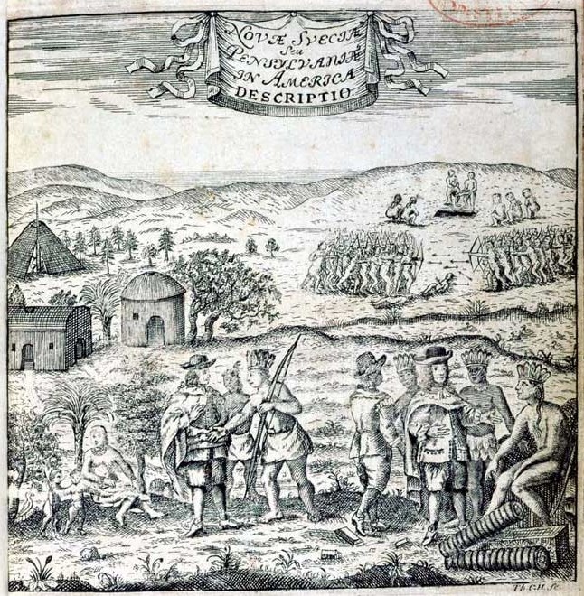
Graphic: Swedish settlers meet the Lenni Lenape people in the meadows along the Schuylkill. Circa 1700. (Collection Historical Society of Pennsylvania; in the public domain)
